As advertising becomes more expensive and consumer groups become more fragmented, some marketing firms are using geospatial data to create geofences in specific areas. This allows them to advertise to audiences who are more likely to become customers while avoiding wasting money marketing to those who likely will not buy from them.
So what does geofencing mean? What is geofencing marketing, and how does geofencing work? What are the specific reasons advertising firms are utilizing it? And how can you take advantage of it for your own marketing efforts? We will answer all these questions and more in the blog.
We will start by explaining in more detail what it means to advertise using geofences, including why it is becoming a popular marketing tool.
What Is Geofencing Marketing and Why Is It Important?
Geofencing marketing involves setting up virtual boundaries around a point or area that track whenever someone with a mobile device crosses them. When this happens, it triggers a notification that advertises a nearby store, brand, service, or product to that person’s mobile device.
This is sometimes also referred to as geofencing advertising. If you are wondering what geofencing is in marketing, it is simply the use of location-based technology to deliver ads based on where someone is physically located.
To understand why this matters, think about how traditional advertising works. A company sends out ads through mass media channels such as TV, radio, newspapers, magazines, and flyers that attempt to appeal to as broad an audience as possible. This is a rather random approach, as the people reached may be just as likely to have no interest in what the company has to offer as they are to actually want the advertised products or services.
In contrast, geofencing allows marketers to define specific spatial boundaries within which their ads will be deployed. This enables them to target nearby people who are more likely to shop at a particular business because of proximity, demographics, brand affinity, and other attributes. Compared to wide-ranging and expensive mass advertising, geofencing marketing is typically more focused and cost-effective.
Geofencing vs. Geotargeting
Although the two terms are sometimes used interchangeably, geofencing and geotargeting are not the same.
Geofencing creates a defined virtual boundary around a specific physical location and triggers a marketing action when someone enters or exits that boundary.
Geotargeting delivers ads to users within broader geographic areas such as cities or ZIP codes and does not rely on real-time boundary crossing.
If your goal is proximity-based engagement and visit attribution, geofencing marketing is often the better option. For broader awareness campaigns, geotargeting may be more appropriate.
How to Implement Geofencing Into Your Marketing Strategy
There are three main ways to create geofences. Understanding how geofencing works in practice can help you implement it more effectively in your marketing strategy.
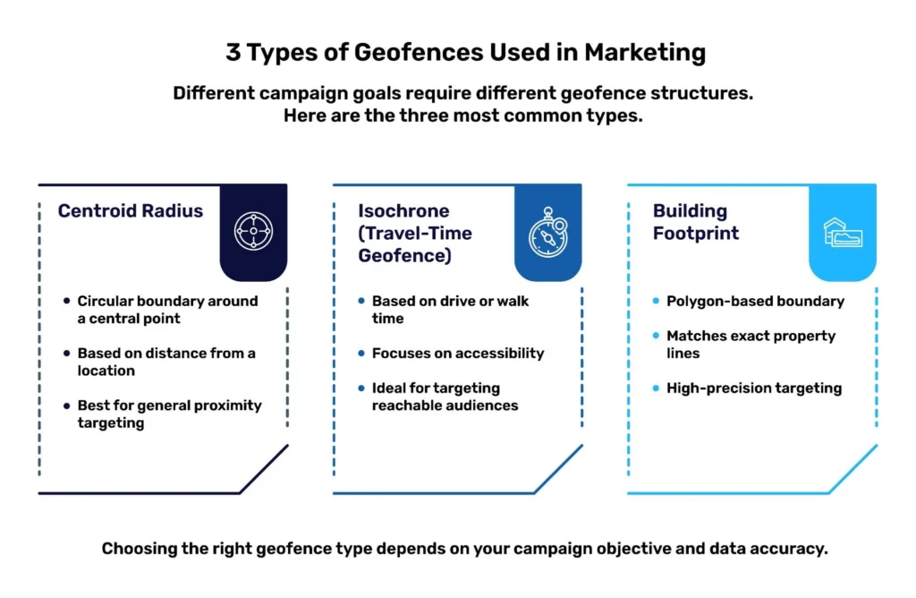
The first is with a centroid radius. This involves locating the center point of a building or property and then calculating a certain distance away from that point, or radius, in every direction. This creates a general proximity zone that will send out ads whenever someone with a mobile device gets sufficiently close to a point of interest.
The second is with a walk or drive time, also known as an isochrone. This involves calculating the amount of time it takes to get to a particular point from any other location using available transportation methods. A company can then send out ads only to people who can travel to their business location within a specified amount of time. This is a more specific type of geofence that allows for marketing based on how easily people can get to a business, rather than simply how close they are.
The third is with building footprints. This method uses measured polygons to represent the exact physical boundaries of a point of interest, whether that is an entire building, a park, or a store unit in a mall. A business can then send notifications only to people who actually set foot inside the building or on the property. This more precisely targets people who, by visiting a business, may already be signaling an intent to buy.
4 Benefits of Geofencing Marketing
We’ve already talked a bit about how geofence-based advertising is different from traditional marketing. Now let’s take a deeper dive into four specific advantages it provides over doing things the old-fashioned way.
1. Timely
One reason that geofencing ads are often superior to traditional ads is that they’re delivered almost instantaneously in response to a potential customer’s actions. As a business owner, you don’t have to wait for someone to read a newspaper or magazine, or be near a TV or radio at a specific time, to be exposed to your ad. As soon as they cross your geofence, you can start marketing to them immediately.
This is also a more relevant time to reach customers, as they are right near where they are able to buy from you. In other words, you don’t have to count on them remembering your advertisement the next time they decide to go shopping in the area near your store.
2. Targeted
Another advantage of advertising with geofences is that they cover specific geographic areas. This allows marketers to deploy them in places where they expect likely customers to be. Contrast that with mass marketing, which is deployed throughout large geographic areas such as cities, regions, or countries. That makes it much more random in its ability to reach interested consumers.
3. Economical
The fact that geofence marketing campaigns can be deployed in precise locations also makes them cost-effective. Mass advertising is expensive because it takes a lot of resources to disseminate a message across a broad geographic area. It is also based on the belief that more exposure is always better.
When marketing with geofences, however, you only have to pay for ads in the specific areas in which you deploy them. If deployed correctly, they can reach a much higher concentration of people who are more likely to become customers.
4. Flexible
Since geofences can be created in a number of different ways, they are also adaptable to your marketing strategy. You can set them up to cover a proximity around your business, or just the grounds of the business itself, so you only advertise to people already inside your store.
You can also set them up for areas within a certain transit time from your business, or at nearby places that get high foot traffic, so people know your business is an accessible option. You can even set up geofences near competitors so that consumers will know your business is an alternative if they do not find what they are looking for at the right price.
How to implement geofencing into your marketing strategy
Marketing is an industry that is increasingly becoming all about personalization, so you can’t just set up geofences randomly around your business and expect to make tons of conversions. You need to understand who your customers are, where they are, where they go, and when they go there. Here are four tips for getting the most out of your marketing geofences.
1. Find out if nearby people are likely to become customers or not
A big issue with mass marketing is that it often blindly reaches out to people who have absolutely no interest in the products or services being offered. But marketing geofences can suffer from the same problem if they’re set up with little regard for who they’re going to target.
That’s why it’s important to research the demographics of nearby populations before you set up your business’s geofences. This will give you hints as to which census block groups are most likely to yield customers, so you can position your geofences accordingly.
2. Base how you construct your geofences on your strategy and scenario
Depending on your marketing strategy and your business’s geographic situation, certain methods of creating geofences may work better for you than others. For instance, let’s say your store is surrounded by competitors you want to take market share away from, or complementary businesses you want to cross-promote with. In this case, you may want to create geofences based on building footprints. This lets you target those exact locations while avoiding other unrelated businesses.
In another scenario, you may want to take advantage of your business being close to one or more popular tourist attractions. Here, you might want to set up radius-based geofences with help from point-of-interest data and property data. Or, if your business is accessible to other nearby areas where people tend to hang out, you may want to create isochrone geofences based on mobility and transportation data.
3. Pay attention to time, too
Just as important as knowing who is close to your business and where they go is knowing when they’re going to be there. You need to calibrate your geofences to deliver appropriate marketing messages for certain times of day. For example, if you run a restaurant, using geofences to advertise your breakfast special when it’s already 8:00 PM is not likely to result in many conversions.
Also keep in mind that people from particular demographics may be more likely to visit specific places at certain times of day or on certain days of the week. So be sure to adjust the messaging your geofences are sending out to target the right people at the right time. Mobility data can help you determine when people visit specific stores or neighborhoods.
4. Make sure your foundational data is accurate and precise
Whether you’re using POI, property, mobility, demographic, or transportation data to inform the building of your advertising geofences, make sure you get it from reliable sources. If your calculations, polygons, or other data are incorrect, you could end up with some very big problems.
For example, you might overextend your geofences’ reach and thus overrepresent your audience. Or you might position your geofences near census block groups that aren’t your target audience. Either way, you will end up overpaying for marketing that is reaching people who are likely not going to become customers anyway.
On the other hand, incorrect data may cause you to set up geofences that are too small or otherwise fail to capture at least some of your target demographics. This may make it look like your advertising campaign was unsuccessful. But the reality is that it simply underperformed because bad data prevented it from reaching the people you most wanted to connect with.
How to Track the Success of Your Geofencing Marketing Campaigns
Whether it uses geofences or not, you’re going to measure how impactful an advertising campaign is in driving sales or other goals for your business. But how you do that when using geofences for marketing may be a bit different from what you’re used to. After all, you’re tracking stats that are based on physical places, but some of them may be digital in nature.
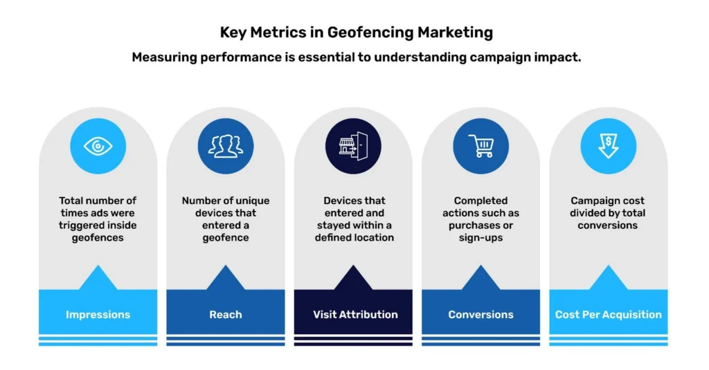
Here are some top metrics to consider:
- Impressions: This is a basic count of the number of times someone with a mobile device crossed into the boundaries of one (or more) of your geofences. In other words, it counts how many times your ads were sent out, regardless of whether or not they were acted upon.
- Reach: This counts the number of unique mobile devices that crossed into the boundaries of one (or more) of your geofences. It is similar to impressions, except that it does not count multiple visits from the same person.
- Visit attribution: This is a measure of how many unique mobile devices crossed a geofence over a certain period of time, and how long each one stayed within the geofence. It’s especially useful if you’re using geofences based on your stores’ building footprints, as you can see how many people actually entered your stores and at least considered making a purchase.
- Conversions: This describes the number of times consumers took an action that your ads prompted them to. Usually, that will involve buying something from your business, but it can be measured in other ways as well. For example, it could include going inside one of your stores (visit attribution) or signing up for a rewards program or newsletter email list.
- Cost per acquisition: This measures how efficient your marketing campaign was at prompting consumers to become customers of your business. It is calculated by taking the total cost of the campaign and dividing it by the number of conversions you received over the course of the campaign. The lower this number is, the better.
Brands effectively using geofencing marketing
So what does advertising using geofences look like in action? Here are a couple of geofencing advertising examples: companies that have honed the precision of their marketing campaigns by using geospatial data.
Billups
Billups was trying to accurately measure impressions and conversions on its outdoor ads. Part of the solution involved cross-referencing anonymized mobile device GPS data with POI data. This allowed them to estimate the route someone took and which billboards they encountered along the way.
Tracking online conversions related to these ad impressions is relatively easy due to web technologies such as cookies. However, it’s more difficult for physical stores because anonymized mobility data can’t always accurately reveal whether a person visited a specific store. The person may have just parked in the parking lot or visited an adjacent store, for example.
That’s why Billups turned to polygon-based property data. They used it to build geofences that matched the building footprints of the stores for which they wanted to measure conversions. This allowed them to determine more accurately whether a person who saw one of their ads visited a particular store.
Media Storm
Media Storm was running advertising campaigns for its clients to re-engage customers who had simply visited stores. The goal was to turn these visitors into purchasers and, ideally, keep them coming back. They began by tracking anonymized GPS locations from mobile devices, but this was not very helpful in determining whether a person had visited a client’s store or even a competitor’s store. The reason was that they did not have accurate information about the precise locations of their clients’ stores or those of their competitors.
Centroid-based proximity models were ineffective as well, especially in crowded environments such as malls or downtown city neighborhoods. They ran the risk of including people unrelated to the conversions of their clients or competitors, including visitors to nearby buildings or pedestrians on the street.
The solution was to use property data based on polygons that matched the building footprints of client and competitor stores to construct geofences. When Media Storm combined this with the anonymized mobility data it had licensed, it was able to determine much more accurately how many people had visited a client’s or competitor’s store while ignoring people who were nearby but were not actual visitors.
There you have it: an introduction to why and how to use geofences to power advertising campaigns. Of course, you’re going to need accurate geospatial data to build them, and a great place to start is with SafeGraph’s Geometry data.