Location sits quietly behind many everyday business decisions. From showing nearby stores to estimating delivery times, companies depend on knowing where something is located and what surrounds it. A Geocoding API plays a central role in making this possible. It translates addresses and place names into geographic coordinates that a data system can better utilize to provide meaningful business insights and actions.
Before understanding how a Geocoding API works to support businesses, let us first look at the basics of geocoding to understand it better.
The Basics of Geocoding
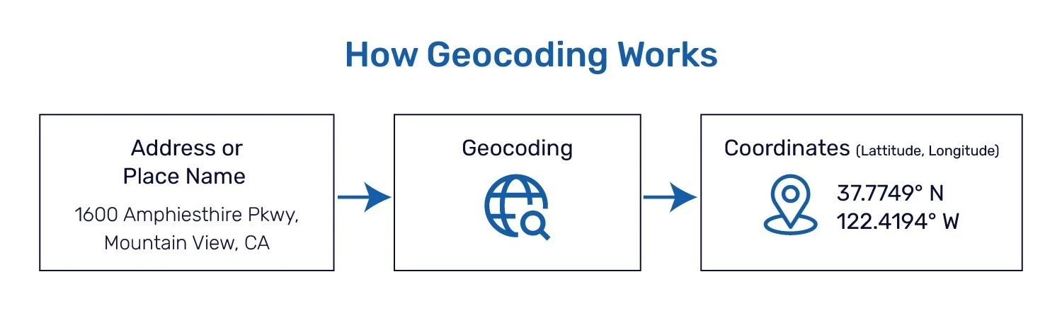
Geocoding is the conversion of written descriptions of a place into geographic coordinates. People might know an address, a historic landmark, or even an area by name, but for data systems, these descriptions are just text. Geocoding converts these texts into latitude and longitude, creating a precise and more consistent reference for a physical location.
The result of this is what we call a geocode. A geocode is not an address. It is the coordinate-based identifier of a place, usingg latitude and longitude. While addresses can change, vary in format, or contain errors, geographic coordinates remain fixed. This is why geocodes are far more reliable for analysis, comparison, and automation.
A Geocoding API is the interface that makes this process usable at scale. It allows applications and data systems to send location inputs such as addresses or place names and receive standardized coordinate outputs in return. Instead of handling geocoding manually, businesses rely on APIs to apply the same logic consistently across volumes of location data.
At this foundational level, geocoding is about structure. It turns descriptive locations into data that systems can store, reuse, and analyze.
What a Geocoding API does in practice
In practice, a Geocoding API handles how location data moves through real workflows. This is where the mechanics of Geocoding become operational.
Geocoding usually works in two directions. Forward Geocoding (typically known just as ‘geocoding’) begins with an address or place name and transforms it into geographic coordinates. This is often used when businesses want to map customer addresses, store networks, service areas, or delivery destinations. After conversion, these locations may easily be visualized and analyzed using distance measures and other analysis that becomes possible with coordinates.
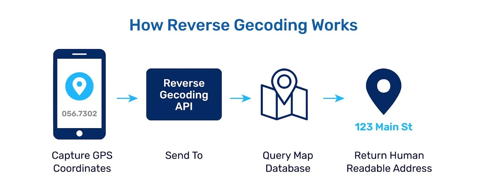
Reverse Geocoding works in the opposite manner. It takes geographic coordinates and translates them back into a human-readable location. This process is often used to contextualize movements – turning location pings from deliveries or users into real-world locations.
A Geocoding API applies both directions automatically and consistently. It ensures that new location data entering a system is processed the same way as existing data. Over time, this creates a reliable location layer that different tools and teams can depend on without repeated cleanup or interpretation.
Rather than being a one-time conversion step, the API becomes part of ongoing operations, quietly standardizing location data as it flows through the business.
Why businesses use a Geocoding API
Businesses often need to start using a Geocoding API when location data becomes a constraint rather than an asset.
As organizations grow, they collect location information from many different sources. Customer records, transaction logs, delivery addresses, partner systems, and third-party data might all describe one common location but in different address strings and place names. These inputs are often incomplete, inconsistent, and difficult to compare. Over time, this fragmentation makes it harder to run location-based analysis.
Addresses alone also limit what businesses can measure. Text descriptions cannot answer questions about distance, proximity, or coverage. Teams may know where customers are in theory, but struggle to understand how locations relate to one another in practice. This creates blind spots in planning, operations, and strategies.
Finally, location data does not scale well when handled manually. As volume increases, so do errors, delays, and operational overhead. Without a standardized way to process locations, businesses find it difficult to maintain accuracy across systems and teams.
These challenges are what pushes the organizations towards a Geocoding API in the first place.
How Geocoding APIs Drive Business Growth
Geocoding APIs address these challenges by turning location into structured, usable data.
When addresses are converted into geographic coordinates, location stops being descriptive and becomes measurable. Businesses can analyze distance, identify clusters, and compare regions using a consistent reference. This shift enables clearer insights into where demand is concentrated and where performance varies.
Operationally, geocoded data supports more efficient workflows. Routes can be optimized, service areas refined, and coverage gaps identified. Over time, all these efficiencies reduce costs and improve customer experience, particularly as scale increases.
Expansion planning is no longer about gut instinct or based on speculation — it is data-driven. New locations, markets, or service zones can be assessed for availability, proximity, and existing demand patterns as predictors before embarking on a major business decision.
In this way, Geocoding APIs improve the quality of decisions that in turn drive growth. Better location data leads to better planning, execution, and long-term outcomes.
Real-World Business Use Cases of Geocoding APIs
Geocoding APIs are used wherever location influences cost, experience, or decision-making. While the applications vary by industry, the underlying value remains the same: turning location descriptions into something measurable, comparable and actionable.
Customer and Market Analysis
Businesses geocode customer addresses to understand where demand is concentrated. When customer locations are mapped and analyzed, patterns emerge that are not visible in spreadsheets. Teams can identify high-performing regions, underserved areas, and geographic differences in behavior. These insights support more focused marketing, pricing, and regional planning.
Logistics, Routing and Service Coverage
Delivery, conveyance, and field activity largely depend on precise location information. These Geocoding APIs allow businesses to map destinations into coordinates, which are easier for planning routes and calculating distances. This contributes to lowering delivery times, fuel consumption, and identification of sensible service areas as business scale.
Address Validation and Data Quality
Issues with incomplete or inconsistent addresses are a common source of operational friction for e-commerce operators and other user applications. Geocoding APIs are thus used to validate user-input addresses and to enhance accuracy across customer records, orders and internal databases. Cleaner location data leads to fewer failed shipments, and more satisfied customers.
Expansion and Site Planning
Geocoding provides an analytical lens through which decisions taken by companies about the location of new stores, warehouses or service zones can be rooted. By taking factors such as customer proximity, access and coverage into account, teams can evaluate future locations before making long-term investments. This mitigates the risk and increases success in growing.
Choosing the Right API
Choosing a geocoding API depends on how location data is used within the business.
Accuracy is essential. Location data must be reliable, especially in regions where addresses vary in structure. Inconsistent results can weaken analysis and lead to poor decision-making.
Coverage matters as well. Businesses operating across multiple regions need consistent performance at different geographic levels, and gaps in coverage can create blind spots. To ensure strong accuracy and coverage, the geocoding API should rely on a high-quality address database, such as SafeGraph’s Address.
Scalability and latency are other key factors. As data volumes grow, the API should be able to handle larger datasets without delays. Finally, geocoded data should integrate easily with existing maps, analytics tools, and operational systems.
How to Get Started with Geocoding
Most businesses already collect address data. The first step is identifying where location affects decisions or operations.
A common starting point is geocoding a single dataset, such as customer or delivery addresses, to assess accuracy and consistency. From there, geocoding can be applied to additional data as needed. Over time, geocoding becomes part of regular data workflows. New location data is processed as it enters the system, keeping the records aligned and ready for analysis.