Hi! I wonder if there is anyone who knows how the monthly patterns dataset distinguish the CBG that a POI is? I compared the boundaries from Chicago data portal and the chicago POIs’ cbgs but I find they do not match?
I might be misunderstanding your question. Are you wondering what geometries we use for our CBGs?
If so, we use the geometries from the 2010-2019 geometries from the ACS, but specifically the 2016 vintage, for the CBGs.
Hi Niki! The Chicago data portal uses 2010 census block boundaries. Yeah I am just not sure why the poi_cbg column looks different from the 2010 census block boundaries information. I noticed the ids are similar but not exactly same, so I guess possible there are different systems
Got it, thanks for the clarification. Mind sharing what the Chicago data portal uses? Might be able to offer some insight.
Definitely! The Chicago data portal uses https://data.cityofchicago.org/Facilities-Geographic-Boundaries/Boundaries-Census-Blocks-2010/mfzt-js4n
Oh, I see. Looks like the city still does use the same format as SafeGraph but is providing additional granularity. This map goes all the way down to Block (whereas SafeGraph goes one resolution higher to Block Group for poi_cbg ).
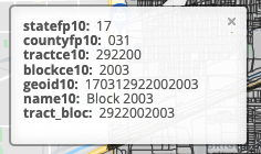
Using this photo and looking at geoid10 , it shows 170312922002003 (15 digits) whereas our data would show 170312922002 (12 digits). Using this map, I’d recommend aggregating from Block to Block Group for an apples to apples comparison with SafeGraph.Let me know if that makes sense.
Thanks for the comparison Niki! I just wonder what do you mean by “aggregating from Block to Block Group for an apples to apples comparison with SafeGraph”? I tried deleting the last 3 digits before, but I am not sure whether it is correct
Hey Yilun - you’re correct. If you take the 15 digit code and remove the last three digits from the above example, that will give you the equivalent format for poi_cbg in our data. Individual census blocks are one resolution smaller than block groups (which is the lowest geographical unit SafeGraph provides data on).
oh, so the cbg used in SafeGraph dataset is actually not the same unit used in the Chicago data portal?
which means we can extract its higher unit to link it to a block group
I thought it is another format. So I just need to delete the last three digits and match them.
Thank you so much Niki! I highly appreciate your help!

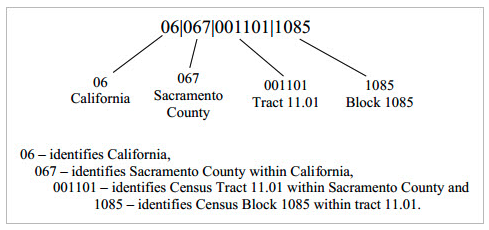
It’s not another format, per se. The 15 digit just provides more detail by going all the way down to the individual block. See this example for more detail:
So our data would stop at the block group:
060670011011
and no problem! glad it helped
Got the example!